Extended QGIS Web Client
This is our modified and extended version of official QGIS Web Client I. It turns your QGIS project into Web and Mobile GIS application with tools to view, navigate, search and print your data. On top of that, there is a PostgreSQL management database for storing projects, layers, users and some specific settings not in QGIS project. Database administration and project browsing is done with – gisportal.
Version: 1.8.2, GitHub (Code and documentation)
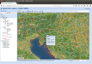
Mobile Client DEMO
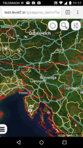
Mobile client is opened automatically on phones, on other screens you can force it with adding mobile=on parameter to URL.
Modifications and new features:
- system for storing and managing clients, projects, external layers (WMS, WMTS, XYZ) and users
- user authorization with different levels (guest, user, administrator)
- easy project configuration
- GIS portal for browsing projects and complete database administration
- loading Web or Mobile client based on screen size
- PDF printing improved with user title, description and inclusion of base layers
- using external API services for geocoding, reverse geocoding and getting point elevation data
- plugins support, currently available:
- Google StreetView
- Editor
- SimpleAction
- layer and group context menu with Zoom to layer extent, Open attribute data, Data Export and Properties
- NEW v1.8.0 layer table synchronized with current map view (optional)
- NEW v1.8.2 works with QGIS Server 3.4 (Linux setup)
- geolocation button
- legend in layer tree
- separating project settings and code
- user Interface changes and many minor improvements